


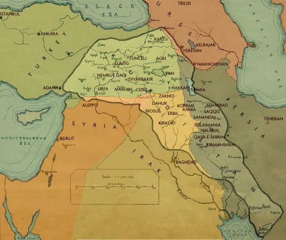
Hey - Just had a look at Heval's site and founda new and improved map of Kurdistan...
I still think whoever made the map forgot to add other West Kurdish areas -
Afrîn and Along the river Firat...
What is your oppinion?


![]() Author: Diri » Thu Jun 30, 2005 11:38 pm
Author: Diri » Thu Jun 30, 2005 11:38 pm


![]() Author: kardox » Fri Jul 01, 2005 2:43 am
Author: kardox » Fri Jul 01, 2005 2:43 am

![]() Author: Diri » Fri Jul 01, 2005 5:02 pm
Author: Diri » Fri Jul 01, 2005 5:02 pm
![]() Author: Diri » Fri Jul 01, 2005 5:05 pm
Author: Diri » Fri Jul 01, 2005 5:05 pm
![]() Author: kardox » Fri Jul 01, 2005 7:46 pm
Author: kardox » Fri Jul 01, 2005 7:46 pm
Diri wrote:The problem is - "Kurds" or what ever you wanna call them - in most southern part of Kurdistan - just North of the Persian Gulf are not nationalist... They have been mostly assimilated...
![]() Author: Heja » Sun Jul 03, 2005 8:07 pm
Author: Heja » Sun Jul 03, 2005 8:07 pm

![]() Author: kardox » Mon Jul 04, 2005 5:41 am
Author: kardox » Mon Jul 04, 2005 5:41 am
Diri wrote:RIGHT! I will do that... WHERE IS HIS E- MAIL ADRESS BROTHER...????
Return to Kurdistan Debates, Articles and Analysis
Registered users: No registered users