


When ever I hear the name Kurdistan from someone or read it in an article, I just wonder whether the speaker or the author have any idea what they are talking about. The dilemma of not providing enough information to the listeners or the reader has made so much damage to the Kurdish national struggle that only the history can make sense of it. No one has every bothered to line up where the Kurdistan frontiers may go. May be that is why we have to explain the Kurdish character of Kurdistan to every one. Many Kurdish organizations still relay on occupiers maps and geographical division to make sense of their existence while we have such a rich untold historical geography.
I was looking at old maps from 16th century at the British museums in London, from Ottoman Empire, I realised that many names we use today was really Kurdish before, Like “Qeredax” even is a last name for many famous Kurdish personalities, was actually called “Tepe Reshan”, or Biarbakir was actually called “Díyar Bekran” which is the name for famous and largest tribe of Bekran in the area. The provisional division of Iran happened only 15 years before the Republic of Kurdistan in Mehabad was establish, in 1931, but today is the source for all Easter Kurds without knowing the enemy made that to divide the Kurdish national struggle. I believe in Kurdish literature “Díyar Bekran”, “Tepe Reshan”, Mukríyan should always be the same no matter what so we educate our future generations with a solid identity, and not changing with what occupiers are imposing.
However, How much do you know of Kurdish geography?
Have a look
http://www.kurdistanica.com/english/geo ... frame.html
http://www.kurdistanica.com/english/geo ... ap-03.html
Facebook

Search

Welcome To Roj Bash Kurdistan

A short lesson in Kurdish Geography
6 posts
• Page 1 of 1
A short lesson in Kurdish Geography
![]() Author: Binyamin » Sun May 29, 2005 4:40 pm
Author: Binyamin » Sun May 29, 2005 4:40 pm
We must be the change, we wish to see.
-Gandhi
(go to my favourite web page http://www.KurdishAcademy.org )
-Gandhi
(go to my favourite web page http://www.KurdishAcademy.org )
-
Binyamin - Nubar

- Posts: 26
- Joined: Tue May 24, 2005 5:27 pm
- Location: UK
- Highscores: 0
- Arcade winning challenges: 0
- Has thanked: 0 time
- Been thanked: 0 time
![]() Author: Diri » Sun May 29, 2005 4:57 pm
Author: Diri » Sun May 29, 2005 4:57 pm
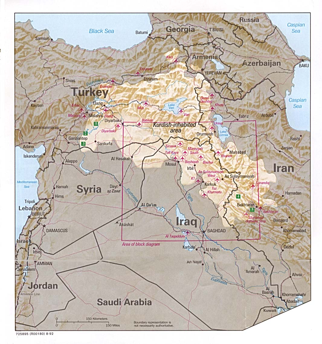
This is a map that is FAR TOO often used - BUT it is TOO SMALL!
http://www.lib.utexas.edu/maps/middle_e ... nds_92.jpg
This is the map that mostly Northern Turks like to go with... it is ONLY right about the Northern Kurdistan - But South and East Kurdistan have been neglected! But if this was ALL we got - I would be happy EVEN with ONLY this...
http://chuot.club.fr/zimages/kurdistan/ ... tanmap.jpg
I have NEVER laughed SO much of JUST looking at a MAP :
http://www.ecn.org/tmcrew/int/kurdi/mappa_kurdistan.jpg
NOW THIS IS POLITICS! - Not sure I like it though...
http://www.kurd.us/map/images/kurdistan ... 9-1998.gif
Anybody know WHERE I can find the REST of this map??? Here you can SEE where I am from - I was Born in Ormî - Serû just west of Ormî is where we have land... On the border between Turkey and Iran - we have land on both sides...
http://www.kurd.us/map/images/kurdistan-map-large.gif


-

Diri - Shaswar

- Posts: 6517
- Joined: Thu May 12, 2005 11:59 am
- Location: Norway
- Highscores: 0
- Arcade winning challenges: 0
- Has thanked: 2 times
- Been thanked: 10 times
- Nationality: Kurd
![]() Author: Vladimir » Sun May 29, 2005 5:05 pm
Author: Vladimir » Sun May 29, 2005 5:05 pm
There are too many much maps, just like there is to much division among the Kurds.
And here are the maps Medya and I collected:
http://northerniraq.info/maps/thumbnails.php?album=1
And here are the maps Medya and I collected:
http://northerniraq.info/maps/thumbnails.php?album=1
The suppression of ethnic cultures and minority religious groups in attempting to forge a modern nation were not unique to Turkey but occurred in very similar ways in its European neighbours - Bruinessen.
-

Vladimir - Shaswar
- Posts: 2036
- Joined: Sun Apr 17, 2005 10:31 am
- Highscores: 0
- Arcade winning challenges: 0
- Has thanked: 0 time
- Been thanked: 2 times
- Nationality: Hispanic
Where I was try to get
![]() Author: Binyamin » Sun May 29, 2005 5:54 pm
Author: Binyamin » Sun May 29, 2005 5:54 pm
I was tying to say whether we have created some thing that every one can stand for. It is not like a person just feel like it and draw some thing on his computer screen. It should scientifically made possible. The only reliable map is this one, which I think that it containes so much information that we can built on it. No one need to tell me that Dírí is from "AzerBaijan Qerbi" as he is from Rewend province in Kurdistan.
http://www.kurdistanica.com/english/geo ... ap-03.html
The other maps are just unreasonably far from academic work but a good art work, there is no Kurdish-ness in them.
http://www.kurdistanica.com/english/geo ... ap-03.html
The other maps are just unreasonably far from academic work but a good art work, there is no Kurdish-ness in them.
We must be the change, we wish to see.
-Gandhi
(go to my favourite web page http://www.KurdishAcademy.org )
-Gandhi
(go to my favourite web page http://www.KurdishAcademy.org )
-
Binyamin - Nubar
- Posts: 26
- Joined: Tue May 24, 2005 5:27 pm
- Location: UK
- Highscores: 0
- Arcade winning challenges: 0
- Has thanked: 0 time
- Been thanked: 0 time

![]() Author: Diri » Sun May 29, 2005 8:15 pm
Author: Diri » Sun May 29, 2005 8:15 pm
Binyamin:
I have seen another version of that same map - it is not yellow but green - AND according to that I am from Culemêrg... Not Rewand... Rewand would be the areas around Rewandiz... I am from East of Culemêrg... and West of Ormî... So therefore I shall produce this map which I am talking about - for you to see....
BUT it is the same map - only thing different is the name of the places and their territory... But I agree with you that THAT is the map we must fight for and THAT is the lands we can claim for...
Kassem -
Yeah dude... Antep IS Kurdistan... And so is Sêwas - only thing is that MANY Kurds were forced OUT of Sêwas... So now Kurds there are mostly assimilated and the rest stayes as a minority...
-
Diri - Shaswar
- Posts: 6517
- Joined: Thu May 12, 2005 11:59 am
- Location: Norway
- Highscores: 0
- Arcade winning challenges: 0
- Has thanked: 2 times
- Been thanked: 10 times
- Nationality: Kurd
6 posts
• Page 1 of 1
Return to Kurdistan Debates, Articles and Analysis
Who is online
Registered users: Bing [Bot], Google [Bot], Majestic-12 [Bot]